The Changing Estuary through Time
Sea level rise and its effect on the landscape
The behaviour of sea level in response to climate change during the last and present interglacial periods and the last ice age in between strongly affected the landscape of the Severn Estuary and the Severn Estuary Levels.
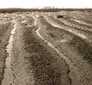
During the last interglacial period, c.125,000 years ago, sea levels in the area of the Bristol Channel and Severn Estuary stood several metres about present levels. Sandy to bouldery beaches formed widely, for example, along the inner margin of the Gwent Levels and around a small, rocky island at Gold Cliff, where they can be examined in the intertidal zone today.
The subsequent last glaciation, when ice sheets advanced from the west and north, reaching Cardiff and Newport, saw sea levels fall by c.135m. The Bristol Channel, Severn Estuary area became land subjected to intense cold. It was not until late glacial times, when deglaciation was advanced and the sea was rising again to shape the Severn Estuary that humans began to exploit the area in any numbers.
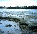
Hunter-gatherers left many traces on the late glacial and Mesolithic (early Holocene) land surface, for example, on the slopes of the island of Gold Cliff, where their hearths, flints and food residues have been found. Some of these traces, buried by later estuarine sediments, have become evident only because of modern coastal erosion. Later and more sedentary prehistoric peoples exploited the wetlands of the developing Severn Estuary as well as the adjoining dry land area. Much evidence of their diverse activities � fishing, hunting, wild-fowling, reed-cutting and, burning, grazing, herding, trackway-building and peat-digging, has been unearthed from the silt and peat deposits beneath the Levels. Like the Romano-British and medieval inhabitants to follow, these people made boats as a means of transport within the estuary and its marsh creeks.
Click Here to view larger version.
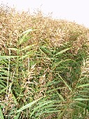
The Severn Estuary and its surrounding wetlands
The Severn Estuary at the head of the Bristol Channel is the largest estuarine system on the British west coast. It lies between the high ground of the Cotswolds-Mendips to the south and southeast and the Monmouthshire hills and Forest of Dean to the northwest. Sediment enters from the seabed to the west and from the substantial catchment of the River Severn and its tributaries. Bordering cliffs and the other rivers that drain into the estuary contribute in a minor way. The estuary is well stirred and highly dynamic, with an extreme tidal range of 14.8m and exposure of prevailing winds. Its waters are notoriously turbid, the amount of suspended mud varying with tidal and weather conditions.
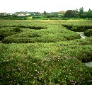
The estuary arose as the periglaciated land area that lay between South Wales and the Cornish Peninsular was transgressed by the rising post-glacial seas (lowstand c.-135m OD). A major consequence of sea-level rise, especially over the last 8,000 years, was that wetlands and their deposits formed close to sea level along the margins of the estuary, creating the extensive Severn Estuary Levels (c.840km2).
Humans have exploited these wetlands in many different ways. Since Roman times, however, the marshes have been largely subject to land-claim (�reclamation�) through the construction of embankments, drains and sluices. Such enclosed marshes, which can be cultivated and permanently settled, are much more valuable than their natural predecessors, but continuing sea level rise makes their defence against flooding increasingly costly. Up to 50 or so years ago, as testified by the many ports and minor landing places on the banks and tributaries, the estuary itself was a major route for communication and trade within Britain and with the Continent and the Americas.